
Welcome to RTHS
The Rideau Township Historical Society (RTHS) was formed in 1974, the same year the historic townships of North Gower and Marlborough were joined to form Rideau Township. The RTHS mission is to "preserve the past to enrich the future" by increasing awareness of and access to the history of the former Rideau Township, which was amalgamated into the City of Ottawa in 2001.
The symbols in the RTHS crest (see above) reflect the pursuits of the early settlers in the area. As illustrated in the images at right, river transport and commerce, forestry, agriculture and livestock were the essential ingredients that enabled the founding townships of North Gower and Marlborough to realize Peace, Plenty and Progress.

Click on the '+' to expand the section and click on the '-' to collapse the section.
What Would You Like to Do Today?


RTHS News, Events & Interests
Upcoming Events
Phil Gurski has published a new book on the Fenian raids on Canada in 1866 through 1871.
This follows his RTHS presentation earlier this year.
The book is available from RTHS. For more information, click on the Books tab above.

Featured Article
The Rideau Canal at Manotick: the Early Years
Article by Ron Wilson in the RTHS newsletter - May, 2009.
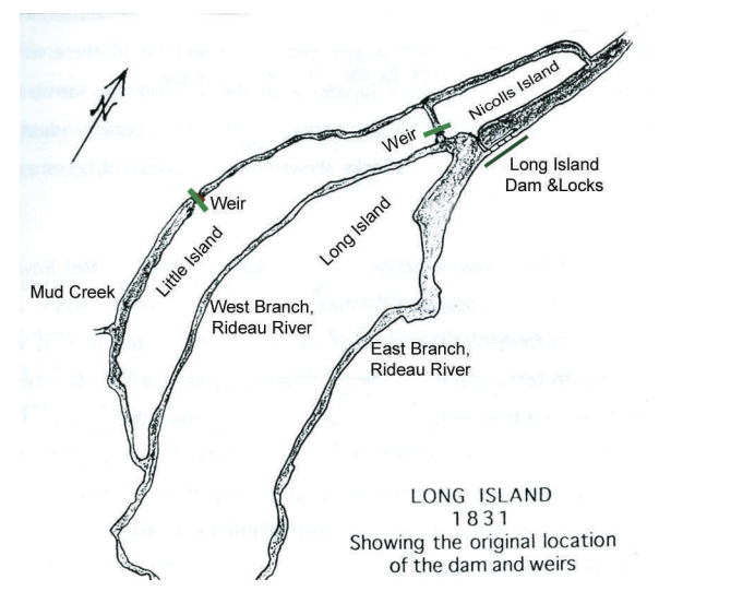
The Rideau Canal opened in 1832, but the bulkhead dam at Watson’s Mill was not built until 1858. This raises the question of how the canal worked in the Manotick – Long Island area in the intervening years.
In fact Colonel By’s design of the canal in the Manotick – Long Island area did not contain a dam at the Watson’s Mill site. He used weirs elsewhere.
A weir is a low head dam used to increase the depth of water in a channel for some purpose. For example a weir could be used to create a mill pond to run a water wheel or yield a section of river navigable. Its not clear when a weir becomes high enough to become a dam.
Before the canal the water flow in the Manotick area was different than now. There were 3 channels instead of two, and there were three islands instead of two. The islands were Long Island, Nicolls Island, and Little Island. The map below shows the area in 1831. (Map from “A History of Long Island, Manotick, 1827 to 1997 by Catherine Carroll & Barbara Humphreys.) Little Island existed because the water levels were higher in both the west branch and Mud Creek before the dam was built at the Watson’s Mill site.
Latest RTHS Publication

A Future RTHS Publication
The History of Manotick, is Being Planned
The RTHS Facebook page continues to add new posts daily (Monday to Friday). A sampling of recent posts include:
- a report on the Pierce's Corners school Marlborough SS#3, from The Weekly Advance, Kemptville in 1907.
- 10,000 at Manotick Fair...9 August 1963, a newspaper page saved by the Manotick Womens' Institute
- a letter published in July 1910 from a girl who came from Britain to North Gower. One of many sent from 1870 to 1939 to alleviate crowding and poverty.
- photo of Noble Watterson House, 5835 First Line Road. built 1900 - 1902
- photo of William Kidd House, 4307Donnelly Drive, Marlborough (c. 1865)
- North Gower Township by-laws in 1950 regarding fences and impounding of stray farm animals
Preserving the Past to Enrich the Future